Why Smart Farming Drones Are Changing the Way UK Growers Work
There is a moment every arable farmer knows, usually in late spring, when the crop looks perfect from the gate but hides trouble in the middle of the field. Patches of poor establishment, a developing weed problem, or an uneven nutrient response can cost thousands at harvest if they go unnoticed until they are obvious to the naked eye. That is exactly the kind of problem that smart farming drones have started to solve, and the change has been quicker and more practical than many expected.
I have spent the past decade working with agricultural technology across the UK, and I have watched drone use move from a novelty to a serious management tool. The first units were awkward, short on battery life, and hard to integrate into a real workflow. The current generation, from manufacturers like DJI Agras, XAG, and SenseFly, is different. These machines carry multispectral sensors, GPS guidance, and flight planning software that can map a field in minutes and produce data that used to require a satellite pass or a very expensive aircraft hire.
The term smart farming drones covers a lot of ground, but in practice it means two things: seeing the crop in ways the eye cannot, and then acting on that information with precision. Remote sensing with NDVI, or normalized difference vegetation index, has become the standard first step. A drone flies a systematic pattern over the field, captures light reflectance across visible and near-infrared bands, and the resulting map shows exactly where the crop is stressed, where it is thriving, and where there are gaps. That map can be loaded into a Geographic Information System, combined with soil data and yield history, and turned into a prescription for variable rate application.
Variable rate application is where the real money is saved. Instead of spreading a uniform rate of fertiliser across an entire field, the drone or the ground spreader follows a digital map that tells it to apply more in one zone and less in another. This is not a theoretical idea. I have seen fields where the savings on nitrogen alone paid for the drone within one season, simply because the grower stopped wasting product on areas that did not need it. The same logic applies to crop protection products. A drone sprayer can target a patch of disease rather than the whole field, which reduces chemical use, lowers the risk of resistance, and keeps more money in the pocket.
One of the most striking developments has been the shift from spraying to spreading. The granular spreader mounted on a drone is not a toy. It can broadcast seed, fertiliser, or slug pellets across difficult terrain that a tractor would struggle to reach. I have watched a DJI Agras T30 spread cover crop seed into a standing maize crop in late summer, something that would have been impossible with a conventional machine without causing serious damage. That kind of operation opens up windows for establishing cover crops that were previously closed, and it does so without compacting the soil.
The practical details matter more than the headline specs. Battery life is still the limiting factor, but the newer models can cover several hectares per charge, and the charging systems have become more robust. Flight planning software has improved to the point where a competent operator can set up a mission in ten minutes, including obstacle avoidance and automatic overlap settings. The data pipeline, from drone to map to prescription, has also become smoother. Many platforms now integrate directly with the same farm management software that records yields and input applications, so the whole system talks to itself.
There is a learning curve, and it is not just about flying. Understanding NDVI maps requires some knowledge of crop physiology and remote sensing. A stress signal can be caused by water, nutrients, disease, or even a change in soil type, and it takes experience to interpret it correctly. This is where a good agronomist or a specialist drone service provider earns their keep. The technology does not replace agronomic judgment; it amplifies it.
Regulation is another layer that growers have to consider. In the UK, the Civil Aviation Authority sets the rules for drone operations, and agricultural work falls under specific permissions that require training and certification. The National Farmers' Union has been active in helping members understand these requirements, and industry bodies have pushed for proportionate rules that allow practical use without compromising safety. The rules are not a barrier, but they do mean that a farmer cannot simply buy a drone and start spraying the next day. Some choose to work with a contractor who holds the necessary permissions, which is often the most sensible route for smaller holdings.
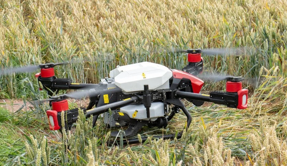
Cost is the question that comes up at every farm meeting I attend. A professional-grade sprayer drone with the associated sensors and software can set you back a five-figure sum, and that is before you factor in training, insurance, and maintenance. But the economics look different when you compare it to the alternative. A tractor-mounted sprayer costs far more, requires a tractor to pull it, and cannot reach into waterlogged fields or steep slopes without causing damage. The drone does not replace the tractor, but it takes over the jobs where a tractor is inefficient, and that is where the return on investment shows up.
I have also seen the environmental benefits play out in practice. The precision that smart farming drones bring means fewer chemicals in the environment, less fertiliser runoff into watercourses, and reduced soil compaction from heavy machinery. Defra has shown increasing interest in how these tools can support sustainable farming practices, and the upcoming changes to agricultural policy are likely to reward growers who can demonstrate environmental stewardship. The data that drones produce can help with that, by providing evidence of targeted applications and reduced input use.
There are trade-offs that do not always make the headlines. Drones are weather dependent, and a windy day can ground a sprayer just when the crop needs attention. The batteries and sensors need care, and the software updates can be frustrating. But the same could be said of any modern piece of farm equipment, and the pace of development suggests these issues will keep shrinking.
Looking ahead, the integration of drone data with other precision agriculture tools is only going to deepen. John Deere has been building its own ecosystem of connected equipment, and while their focus has historically been on larger machines, the data standards they promote are making it easier to move prescription maps between different brands and systems. Parrot, through its multispectral cameras, has made remote sensing accessible to a much wider audience, and their sensors are now common on third-party drones as well as their own.
There is also a growing body of practical knowledge among UK growers who have adopted these tools early. I have spoken to farmers in East Anglia who use drones to map potato blight pressure, in the Scottish Borders who spread lime on rough hill ground with a granular spreader, and in the Midlands who have cut their herbicide use by a third after using NDVI maps to target sterile brome patches. These are not early adopters chasing technology for its own sake. They are practical people who have found a tool that pays its way.
If you are thinking about using smart farming drones on your own land, the best starting point is not a specification sheet. It is a conversation with someone who has done the job in your area, or a trial flight over one of your fields to see what the data actually looks like. The technology is mature enough that the question is no longer whether drones can be useful in farming. It is how quickly you can integrate them into the way you already work.